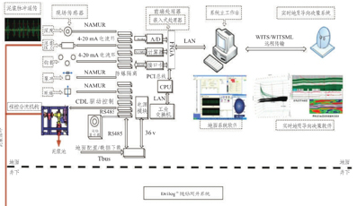
Drilog® LWD SystemThe Drilog® LWD System developed by COSL could support MWD, LWD, directional drilling, geosteering and other engineering application. Drilog® system consists of the surface system and the downhole tools, both of which are equipped with two-way information communication function, and could upload the downhole information in real time and downlink the operation instruction. The system adopts (WITS/WITSML) data format to realize remote transmission, and could transmit the operating data of the well site into the basement of the Company and connect to the real-time expert decision-making system (RTC). It could provide directional measurement data and other parameters required by the monitoring of the formation evaluation, geo-steering and the state of the downhole tool and others while drilling through the real-time MWD and LWD tools. The real-time engineering parameters include: inclination, azimuth, tool face, drilling rig vibration monitoring, well drilling pressure (annulus pressure, pressure within drill stem, well diameter measurement) et.; real-time geological parameters include: natural gamma, electrical resistivity, formation density, neutron porosity, sonic wave, formation pressure, etc. Drilog® downhole tools adopts modular design, and could be connected through customized tool bus (TBus), which can be combined flexibly as required. The downhole tools mainly includes: MWD system, downhole status monitor (DSM), resistivity gamma logging tool (ACPR), instant formation pressure tester (IFPT), instant neutron porosity(INP), monopole array sonic tool (MAST), lithology density imaging (LDI), etc. Drilog® LWD system could be connected to Welleader® rotary steering drilling system, and could realize the integration of LWD and directional drilling as well as geosteering function. Real-time data transmission Drilog® system could upload the measured data of the downhole tools in real time, and select PA or PI modulation mode according to the operating situation, with the uploading rate of up to 3bps. The surface system could make flexible configuration to the coding scheme, transmission rate, uploaded contents and other parameters uploaded from downhole before the tools is run down. The surface system could downlink the operation commands by changing the mud displacement within the circulating channel, and adjust the downhole working mode and mud upload parameters in real time. Trajectory Measurement TMP directional probe adopts three-axis quartz accelerometer and three-axis fluxgate sensor, and measures the high-precision borehole position and motor tool face, and utilizes the mud pulser to upload the measured data in real time. The surface system makes fitting calculation of the borehole position data, and obtains the actual drilling trajectory. TMP probe could provide continuous tool face measurement to help the directional drilling engineer to make decision and adjust the trajectory in realtime. Downhole monitoring and drilling optimization VSM module could measure the vibration of the downhole drilling tool and make real-time analysis, and could adjust the drilling pressure and other drilling parameters in a timely manner if the vibration of the downhole drilling tool exceeds the limits, thus reducing the downhole risks. DPM module could measure the annulus pressure and pressure within the column in real time, and monitor the changes in mud density, borehole cleanliness, sand return and other parameters, thus finding leakage, well kick and other downhole risks in a timely manner. USD module could obtain the well diameter data at the first time during drilling, and could provide reference for adjusting the drilling parameters as well as provide accurate correction parameters for the processing of LWD data. Real-time formation evaluation Drilog® system can be connected to ACPR, INP, LDI, MAST, IFPT and other LWD instrument, and could provide natural gamma, electromagnetic wave resistivity, neutron porosity, lithology density, formation pressure and other LWD data, and could complete formation evaluation at the first time that the borehole is drilled out. All the logging data are stored in the Flash memory that comes with the instrument while uploading such data in real time through the mud pulser, and then download and process when the instrument gets out of the well, thus getting more details about the formation. Geosteering During the landing and horizontal drilling, the Drilog® logging curve is used to adjust the pre-import geological model preset in advance in real time, making the simulated logging curve the same as the measured curved so that the formation characteristics of the drilled formation is identical with that of the pre-import model, thus predicting the distribution of the formation to be drilled, adjusting the drilling trajectory in a timely manner, and improving the landing success rate and the reservoir-encountered rate. Drilog® system could send back the measured data through WITS/WITSML in real time to the expert system, realizing the remote geosteering. |